


| 详细参数 | ||||||||||||||||||||||||||||||||||||||||||||||||||||||
|
| 详细参数 | ||||||||||||||||||||||||||||||||||||||||||||||||||||||
|
|  | | |||||||||||||||||||||||||||
Color & Touch display and Leica FlexField plus onboard software Work productively with the new Leica FlexField plus onboard software and the new color & touch display.
With PinPoint EDM, FlexLine plus delivers the optimal balance of range, accuracy, reliability, beam visibility, laser dot size and measurement time.
Theft protection by Leica Geosystems – mySecurity
| |||||||||||||||||||||||||||||
 徠卡的FlexLine TS06plus全站儀非常適合中高精確度的應用。全字母數字鍵盤,並內置藍牙,USB主機和設備主板提供客戶最高的使用性。
| TS02plus | TS06plus | TS09plus | Viva TS11 | |
| 1" angular accuracy | - | o | o | o |
| Enhanced measurement accuracy to prism | 1.5 mm + 2 ppm | 1.5 mm + 2 ppm | 1.5 mm + 2 ppm | 1.0 mm + 1.5 ppm |
| Reflectorless measurement range | 500 m option | 500 m included / 1000 m option | 500 m included / 1000 m option | 500 m included / 1000 m option |
| Display with graphics and display illumination | Black & White high resolution | Black & White high resolution | Q-VGA Color & Touch | Full-VGA Color & Touch |
| Full alpha-numerical keyboard with function keys | - |  | | |
| Second Keyboard | o | o | o | o |
| Keyboard illumination | - | - | | |
| Electronic Guide Light | - | o | | |
| USB Type A and mini B | - | | | |
| Bluetooth® Wireless | - | | | |
| SD Card | - | - | - | |
| Imaging capability | - | - | - | o |
| Smart Station capability | - | - | - | o |
| Onboard software (package content) | FlexField plus (standard) | FlexField plus (advanced) | FlexField plus (full) | SmartWorx Viva (pro |
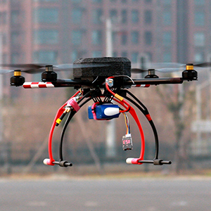
硬件性能 | |
重量 | 1.6kg |
腳架尺寸 | 50 x 41.5 x 32cm |
對稱電機軌距 | 0.8m |
單臂長度 | 0.35m |
中心架直徑 | 0.24m |
電池 | 鋰聚合物電池,11.1V ,8000mAh |
飛行參數 | |
飛行速度 | 70km/h |
飛行高度 | 100 - 2000 m |
續航時間 | 30 -60 min |
任務距離 | 40km |
起飛/ 降落 | |
起飛 | 垂直起飛 |
降落 | 垂直降落 |
天氣條件 | |
風 | 四級以下 |
雨 | 小雨 |


